
Plan Your Visit
Abingdon Traditional Craft Fair will be taking place from Friday 31st October to Sunday 2nd November 2025
The Abingdon Traditional Craft Fair will be open at the following times:
Friday 10:00am to 4:30pm (last entry at 4pm)
Saturday 10:00am to 4:30pm (last entry at 4pm)
Sunday 10:00am to 4:00pm (last entry at 3.30pm)
Access:
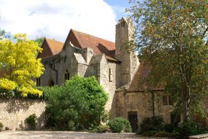
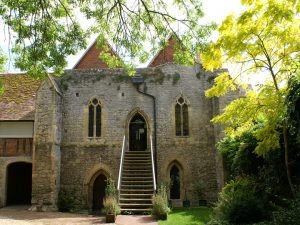
The buildings were built by the monks of Abingdon Abbey roughly eight hundred years ago and, because of their age and the importance of the delicate architecture, it presents challenges in providing modern access facilities. Unfortunately there is no lift to the upper floors so access to approximately half of the stalls (East and West Checker, Long Gallery) is via steep staircases inside the building. The rest of the stalls are on the ground floor with ramp access.
Dogs
Your dog is allowed on the site, provided it is on a lead and under control at all times. However dogs are not allowed inside the Buildings (including the marquees) as these can be crowded - dogs and their leads can cause people to trip. An exception is made for a guide dog for your own use (or a trainee guide dog) wearing appropriate identification.
There are places to sit in the Courtyard with a dog and a drinking bowl will be provided.
There is nowhere on the site that is suitable for a dog toilet so please take your dog for a walk before bringing them into the event - there are many good walks adjacent to the Abbey Buildings including the riverbank (park at Rye Farm) and the Abbey Gardens park and meadows (park at Abbey Close).
Parking and Electric Charging Points
There is no parking at the venue. There are several car parks in the town centre. From Hales Meadow, Rye Farm, Abbey Close, Cattle Market and Civic car parks it is a few minutes walk (less than 5 for an average person walking). Most town centre car parks offer a one hour free ticket but we would suggest that this is not sufficient time to fully enjoy the event (it would work out at less than a minute to look at each stall!) and advise you to purchase a ticket lasting at least two hours; more if you want to enjoy a snack in our tea tent. When you purchase a ticket at the car park machine you can use a card or cash, and you will need to input your registration number. There is more information about town car parks on the district council website here.
If you need to charge up your electric vehicle there is information about where charging points can be found here.
.
How to Find Us
Your destination is Checker Walk off Abbey Close. Use OX14 3JD for driving (Abbey Close car park) and OX14 3JB if walking from the bus stop or a car park in the town.
Directions by car from North/Oxford/A34 Lodge Hill Junction: Head for Abingdon town centre and take the turn for Abbey Close at the traffic lights on the Vineyard. At busy periods the car parks ahead of you (Cattle Market and Civic) are easier to park in. From here walk through the park or into Abbey Close to get round the large redbrick council building ahead of you.
If you need to drop someone closer to the event entrance, take the right fork outside Waitrose, then follow Abbey Close around as it passes in front of the modern part of the Guildhall building and curves to the left down a narrow lane. Follow this to the end to find Abbey Close car park, park and walk the few yards back up the road to Checker Walk. The event entrance is just a few yards down Checker Walk.
Directions by car from South/Didcot/Newbury/A34 Marcham Interchange: From the Marcham Interchange follow signs to Abingdon town centre heading straight on at the double mini roundabouts until forced to turn left at the traffic lights onto Stratton Way. Continue through the next set of lights but then turn right at the lights shortly afterwards to pass Waitrose on your left.. There are car parks ahead of you on left and right (Civic and Cattle Market). After parking up, walk across in front of the main door of Abbey House and on to the roadside pavement of Abbey Close. Turn left, walk 100yds ahead passing the cinema on your right. Turn down the continuation of Abbey Close on the left and look out for the turning into Checker Walk on the right. The event entrance is just a few yards down Checker Walk.
Directions by car from East/Wallingford/Benson/Stadhampton/M40: Approach Abingdon town centre on the A415 and use one of the car parks on either side of the road just before the bridge (Hales Meadow and Rye Farm). This will save having to go around the one way system and is only three minutes walk from the venue. From the car parks proceed over the bridge then straight ahead up Bridge Street until you reach the church tower and turn right to pass under the large archway. Then keep straight ahead to walk down the narrow lane (Abbey Close) looking out for the turning into Checker Walk on the right. The event entrance is just a few yards down Checker Walk.
There is also an even quicker walk by turning right into Thames Street, just after the bridge, walking almost to the end of the street, then passing through the narrow passage in the buildings on your left but please note there are steep steps and a very narrow passageway on this route.
By bus from Oxford: 20 minutes bus ride to Abingdon from the stop outside Christchurch on St Aldates. Arriving in Abingdon walk up the High Street past the Market Place then cross Bridge Street to pass under the archway next to the church tower. Then keep straight ahead to walk down the narrow lane (Abbey Close) looking out for the turning into Checker Walk on the right. The event entrance is just a few yards down Checker Walk. Approximately 5 minutes walk from bus stop.
If you are an exhibitor please click here for directions to the unloading spaces outside the Abbey Buildings